Aviation aerodynamics
We offer a number of aerodynamic services related to the operation of aircrafts and planning of aircraft related facilities.
Wind conditions at airports in mountainous terrain
For airports, airfields and landing strips in hilly or mountainous terrain, it is imperative to establish the flow conditions in order to assess the operational limitations for various combinations of wind speeds and direction. In addition, it is important to evaluate the regularity of the given facility.Operations at airports and airstrips
At an airport located in mountainous terrain planes taking off and landing may be subjected to significant terrain-induced turbulence and "wind shear", which can cause discomfort to the occupants due to high acceleration forces (vibrations) and at worst can cause the pilot to lose control of the air craft. The risk of the latter is greatest during landing when the aircraft is moving at low speed and the engines at idle or low speed, and the aircraft's manoeuvrability is therefore reduced significantly.Wind tunnel simulations
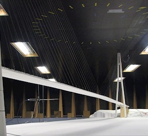
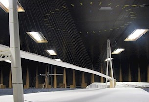
In the wide boundary-layer wind tunnel, we are able to test large-scale terrain models with a detailed representation of the airport or airfield and its surroundings. Our tests provide the operators with an accurate description of the wind conditions for aircrafts arriving at or departing from the airport.
Measurements of the varying wind and turbulence along the approach line are made with a 3-dimensional "flying hot-wire", which with at a very high logging frequency measures three velocity components perpendicular to each other. The probe is oriented so that the three velocity components correspond to wind along the aircraft’s approach direction, horizontal and vertical crosswind and along wind components.
The measured time series may be used as direct input in flight simulators, or used in analysis to assess turbulence levels that can be expected during approach
In addition, the tests may provide the wind conditions for planned positons of anemometers at or near the airport and compare these with existing meteorological stations in the site’s vicinity.
Based on digital maps of the site the terrain surface is described using 3D CAD-software. From this software milling files for our automatic milling machine are generated. This permits a fast and precise model production. The terrain model investigations are normally conducted for areas covering several kilometres. Typical model scales are 1:1000 to 1:2000.
The experimental approach to evaluate the wind conditions at airports is cost and time effective.
Turbulence Warning Indicator (TWI)
TWI Features
TWI offers a real-time indication of the severity of terrain-induced wind shear/turbulence, which an aircraft is expected to encounter on its approach to or departure from the airport, under the governing ambient wind conditions. TWI is particularly suitable for airports situated in mountainous terrain, where local wind measurements at the airport give a poor indication of the wind conditions in the approach and departure corridors.
TWI typically runs on a dedicated display unit installed in the Air Traffic Control (ATC) tower together with other meteorological displays and will advise the ATC operator with regard to alerts or cautions to be conveyed to the pilot on the approaching or departing aircraft. The level of information to be given will be agreed in each case depending on local conditions.
TWI supports both tactical and strategic decision-making and thus helps to enhance flight safety and operational efficiency.
What is involved in setting up TWI for a specific airport?
As part of the preparations for the TWI at a specific airport a detailed wind tunnel study is performed, along with a limited scope of wind measurements on site, in order to get the necessary insight into the wind conditions along the approach and departure corridors. This survey typically includes an area within 8 to 10 km from the runways, and is tailored to match the specific site conditions.
With this information in hand, suitable redundant ground anemometer sites are selected. This selection is critical as the anemometer locations must be such that reliable, unambiguous information about the ambient wind conditions is obtained at all times. The anemometer sites may be located far from the airport and data transmitted to the ATC tower by reliable channels. The wind tunnel study and site measurements provide input to the TWI-algorithm, which interprets the continuous anemometer data and converts it into wind shear and turbulence alerts or cautions, which are displayed at the ATC console.
In its present version the TWI uses the standard turbulence scale from the International Civil Aviation Organization (ICAO), which does not take into consideration that different aircraft sizes react differently to the same turbulence level. However, any other notation or standard may easily be implemented.
It is highly recommended, although not part of the standard supply, to perform test flights with suitably instrumented aircraft in order to "calibrate" or tune the TWI-algorithms for the specific location and specific aircraft sizes. Another option is to test the system in a flight simulator, as has been done on one occasion.
Helicopter operation investigations
A large number of ships, offshore vessels and offshore structures are equipped with a helicopter landing deck or helicopter operation zones (or winching zones). Also certain buildings such as hospitals may be equipped with helicopter decks. The helicopter decks and operation zones can be used for commercial, exploration or safety purposes.
Especially for safety purposes, a permanent serviceability even under difficult and adverse wind and perhaps sea states is of paramount importance.
The wind-tunnel test programme is determined in close collaboration with the client.
- qualitative investigation of the 3-dimensional flow field by means of flow visualization
- quantitative investigation of the flow components locally at numerous points above the helicopter landing deck, operation zone or along an approach or takeoff path
- analysis of the measured data with respect to aircraft response to gusty wind and performance limits in general and with respect to the particular aircraft
- consideration of limiting effects due to plume dispersion and interference with helicopter flight paths
- consideration of superstructure particularities